
Masfaalt
Driving rules
Masfaalt traffic drives on the left side of the road, and is required to keep clear of the inner most lane except when passing slower vehicles.
Speed in Masfaalt is regulated in kilometers per hour (km/h). Due to it being an island and therefore not having land borders, national speed limits are posted at the exits of international ports and airports, as well as being present on the driver's license in a simplified manner.
| Urban: 40 km/h | Heavy vehicles: 80 km/h |
|---|---|
| Gravel road: 60 km/h | Paved road: 80 km/h |
| Expressway: 90 km/h | Motorway: 110 km/h |
Road infrastructure is generally well maintained as it receives regular funding, especially near Vidirholl and Hvammstangi, the two main cities of the island. On top of that, the Masfaalt Ring Road is constantly being expanded, with the end goal of the entire highway eventually being an uninterrupted expressway.
Vehicles carrying dangerous goods may only drive on motorways, expressways, and routes indicated as appropiate for these vehicles. Such routes are distinguished by signs featuring a yellow diamond on a green background.
Road numbering and network
Roads in Masfaalt have either two or three numbers, with the only expection being ![]() , which circles around the entire island.
, which circles around the entire island.
The first number is determined by the province where the road starts, with the numbers being assigned clockwise:
- Forn-Masfaalt (Vidirholl)
- (Rafnseyri)
- (Modreuvellir)
- (Hvammstangi)
- (Fljótmijri)
The Masfaalt Ring Road is comprised of ![]() between Vidirholl and Fljótmijri,
between Vidirholl and Fljótmijri, ![]() between Hvammstangi and Lundarbrekka, and
between Hvammstangi and Lundarbrekka, and ![]() in all other points, as this route goes parallel to the island's coastline.
in all other points, as this route goes parallel to the island's coastline.
Despite all but one roads following the same numbering scheme, six classes exist:
 : motorway.
 : expressway.
 : national road, hazardous transit route.
 : national road.
 : local road.
 : four-wheel drive road.
A road with two digits is more relevant for inter-regional transport, while routes with three digits are more oriented towards connections within each province.
Four-wheel drive roads are unnumbered and most often referred to by the locations that they serve. These are usually trails with challenging features and that may not or have not been upgraded to, at the very least, a gravel track. They can include fords (unbridged river crossings) and uneven road surfaces, and most vehicles are banned from using these kinds of roads. There are no 4x4 roads within the national network.
Below is a map of the Masfaalt road network:
Vehicle registration
Black background license plates stopped being used in the early 1980's.
The letters Á, Ð, É, Í, Ó, Ú, Ý, Þ, Æ and Ö are excluded from use in license plates, except for region codes.

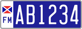 : passenger vehicle.
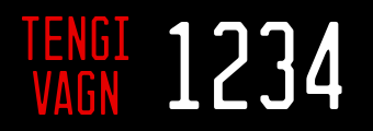
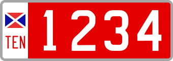 : trailer.

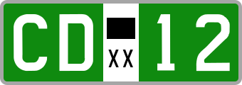 : diplomatic corps vehicle.
The letters XX and the black rectangle are placeholders for the country's code and flag belonging to the diplomat.
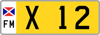 : emergency response vehicle.
The letter X can be any of the following:- A: fire department.
- B: police department.
- C: ambulance.
- D: military vehicle.
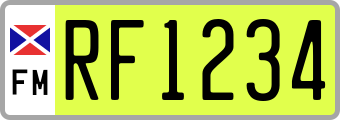 : electric vehicle.